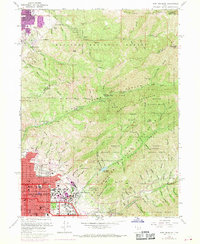
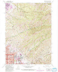
1963 Map of Fort Douglas
USGS Topo · Published 1970About this map
Fort Douglas and the University of Utah define the transition from the grid of Salt Lake City to the steep draws of the Wasatch National Forest. The 1960s footprint shows significant institutional expansion, including University Village and the Veterans Hospital, while the surrounding mountainsides are marked by the industrial and recreational legacy of the region. Notable landmarks include the City Cemetery and Mt Olivet Cemetery, alongside numerous neighborhood schools like Judge Mem High Sch and East H S. Above the residential blocks, the landscape turns to rugged canyons and gulches, such as Cephalopod Gulch and Limekiln Gulch, which underscore the geological character of the range. Small-scale mining operations like the Treasure Box Mine and Burro Mine are scattered near the Sessions Mountains, while water management is evidenced by the Red Butte Reservoir and the municipal Filtration Plant along City Creek.
Find a feature on this map
95 named features on this map. Tap any name to fly to it.
Don’t see what you’re looking for? This feature index may not catch every label — zoom into the map to look around manually.
Map Details
Editions of this 1963 Fort Douglas Map
5 editions found
Other maps of this area

1885 · Salt Lake
USGS Topo · 1:250,000

1925 · Ft. Douglas
USGS Topo · 1:125,000

1928 · Ft. Douglas
USGS Topo · 1:125,000

1950 · Fort Douglas
USGS Topo · 1:24,000

1951 · Fort Douglas
USGS Topo · 1:24,000

1951 · Salt Lake City South
USGS Topo · 1:24,000

1951 · Salt Lake City North
USGS Topo · 1:24,000

1952 · Sugar House
USGS Topo · 1:24,000

1952 · Farmington
USGS Topo · 1:24,000

1952 · Bountiful Peak
USGS Topo · 1:24,000