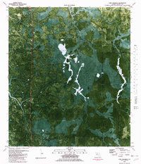
1981 Map of Fort Gadsden
USGS Topo · Published 1982About this map
Fort Gadsden stands at the western edge of this orthophotomap, marking a site of significant military and regional history along the river corridor. The surrounding landscape of the Apalachicola National Forest is defined by the dense, saturated wetlands of Tates Hell Swamp and Juniper Cove Swamp. This 1981 survey utilizes aerial photography to document the intricate drainage networks of Whiskey George Creek and Juniper Creek, which thread through the forest floor.
Find a feature on this map
16 named features on this map. Tap any name to fly to it.
Don’t see what you’re looking for? This feature index may not catch every label — zoom into the map to look around manually.
Map Details
Editions of this 1981 Fort Gadsden Map
This is the sole edition of this map. No revisions or reprints were ever made.
Other maps of this area

1943 · Jackson River
USGS Topo · 1:24,000

1944 · Green Point
USGS Topo · 1:31,680

1944 · Forbes Island
USGS Topo · 1:24,000

1945 · Forbes Island
USGS Topo · 1:31,680

1945 · Kennedy Creek
USGS Topo · 1:31,680

1945 · Tates Hell Swamp
USGS Topo · 1:31,680

1945 · Beverly
USGS Topo · 1:31,680

1945 · Jackson River
USGS Topo · 1:31,680

1945 · Fort Gadsden
USGS Topo · 1:31,680

1946 · Sumatra
USGS Topo · 1:31,680