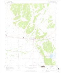
1967 Map of Fort Garland
USGS Topo · Published 1971About this map
The historical Old Fort Garland Military Reservation serves as the focal point of this San Luis Valley landscape, situated where the valley floor meets the slopes of the Sangre de Cristo Range. This 1967 survey documents the critical water management systems essential to the Sangre de Cristo Grant, featuring the Trinchera Diversion Canal and Highline Canal which redirect flows from Trinchera Creek and Ute Creek.
Find a feature on this map
31 named features on this map. Tap any name to fly to it.
Don’t see what you’re looking for? This feature index may not catch every label — zoom into the map to look around manually.
Map Details
Editions of this 1967 Fort Garland Map
3 editions found
Other maps of this area

1889 · Huerfano Park
USGS Topo · 1:125,000

1892 · Huerfano Park
USGS Topo · 1:125,000

1954 · Trinidad
USGS Topo · 1:250,000

1955 · Trinidad
USGS Topo · 1:250,000

1958 · Trinidad
USGS Topo · 1:250,000

1959 · Trinidad
USGS Topo · 1:250,000

1965 · Blanca
USGS Topo · 1:24,000

1965 · Blanca SE
USGS Topo · 1:24,000

1965 · Twin Peaks
USGS Topo · 1:24,000

1967 · Fort Garland SW
USGS Topo · 1:24,000