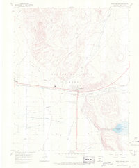
1967 Map of Fort Garland
USGS Topo · Published 1971About this map
The Old Fort Garland Military Reservation (Museum) serves as the historic anchor for this portion of the Sangre de Cristo Grant during the late 1960s. The landscape reflects a legacy of frontier defense and high-altitude agriculture, where the Denver and Rio Grande Western railroad cuts across the San Luis Valley floor. To the east, the foothills of the Sangre de Cristo Mountains give way to a complex irrigation network of ditches and canals, including the Trinchera Canal and Garland Ditch, which redirect water from alpine sources like Ute Creek toward the valley's ranching operations.
Find a feature on this map
27 named features on this map. Tap any name to fly to it.
Don’t see what you’re looking for? This feature index may not catch every label — zoom into the map to look around manually.
Map Details
Editions of this 1967 Fort Garland Map
3 editions found
Other maps of this area

1889 · Huerfano Park
USGS Topo · 1:125,000

1892 · Huerfano Park
USGS Topo · 1:125,000

1954 · Trinidad
USGS Topo · 1:250,000

1955 · Trinidad
USGS Topo · 1:250,000

1958 · Trinidad
USGS Topo · 1:250,000

1959 · Trinidad
USGS Topo · 1:250,000

1965 · Blanca
USGS Topo · 1:24,000

1965 · Blanca SE
USGS Topo · 1:24,000

1965 · Twin Peaks
USGS Topo · 1:24,000

1967 · Fort Garland SW
USGS Topo · 1:24,000