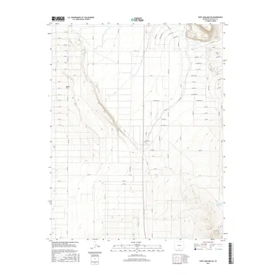
2016 Map of Fort Garland SW
USGS Topo · Published 2016About this map
The Basaltic Hills rise above a strictly gridded agricultural landscape in this southwestern portion of Costilla County. This 2016 survey highlights a complex irrigation network essential for high-altitude farming in the San Luis Valley, featuring major waterways such as the Sangre de Cristo Ditch Number 3, the Trinchera Canal, and the Highline Canal. These man-made channels snake across the terrain, diverging from natural water sources like Ojito Cr to serve the expansive grid of roads, including Ute Ave and Aztec Ave. The southern reaches of the map are defined by the presence of the Willow Cr Reservoir, a critical catchment point near the base of the surrounding mountain ranges. This map captures the intersection of early water rights and modern rural development, where the geometry of the road system meets the sinuous path of historic Colorado water infrastructure.
Find a feature on this map
95 named features on this map. Tap any name to fly to it.
Don’t see what you’re looking for? This feature index may not catch every label — zoom into the map to look around manually.
Map Details
Editions of this 2016 Fort Garland SW Map
This is the sole edition of this map. No revisions or reprints were ever made.
Other maps of this area

1954 · Trinidad
USGS Topo · 1:250,000

1955 · Trinidad
USGS Topo · 1:250,000

1958 · Trinidad
USGS Topo · 1:250,000

1959 · Trinidad
USGS Topo · 1:250,000

1965 · Blanca
USGS Topo · 1:24,000

1965 · Blanca SE
USGS Topo · 1:24,000

1967 · San Luis
USGS Topo · 1:24,000

1967 · Fort Garland SW
USGS Topo · 1:24,000

1967 · Ojito Peak
USGS Topo · 1:24,000
1967 · Trinchera Ranch
USGS Topo · 1:24,000