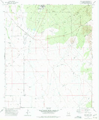
1972 Map of Fort Grant
USGS Topo · Published 1975About this map
Fort Grant serves as a focal point for this 1970s survey, marking a transition from its origins as a frontier outpost to its mid-century role as the State Industrial School. The map reveals the intricate water management required in this arid Graham County landscape, where an aqueduct and numerous wells support local operations. Significant historical boundaries are clearly delineated, including the Fort Grant Military Reservation Bdy and the edge of the Coronado National Forest.
Find a feature on this map
36 named features on this map. Tap any name to fly to it.
Don’t see what you’re looking for? This feature index may not catch every label — zoom into the map to look around manually.
Map Details
Editions of this 1972 Fort Grant Map
This is the sole edition of this map. No revisions or reprints were ever made.
Other maps of this area

1922 · Willcox
USGS Topo · 1:125,000

1940 · Sierra Bonita Ranch
USGS Topo · 1:62,500

1942 · Sierra Bonita Ranch
USGS Topo · 1:62,500

1942 · Mt. Graham
USGS Topo · 1:62,500

1943 · Willcox
USGS Topo · 1:62,500

1943 · Sierra Bonita Ranch
USGS Topo · 1:62,500

1943 · Winchester Mts.
USGS Topo · 1:62,500

1945 · Mt. Graham
USGS Topo · 1:62,500

1945 · Winchester Mts.
USGS Topo · 1:62,500

1954 · Silver City
USGS Topo · 1:250,000