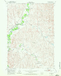
1953 Map of Fort Reno
USGS Topo · Published 1972About this map
The Bozeman Trail cuts a diagnostic path through this Wyoming landscape, marking a legacy of western migration and military presence in Johnson County. At the heart of this 1953 survey is the site of Fort Reno and the nearby Mc Kinney Military Res, both designated as abandoned or historical locations by the time of mapping. The terrain is defined by the winding course of the Powder River and a network of draws including Jepson Draw and Reno Draw. The human geography of the era is represented by a series of isolated outposts such as the Reculusa Ranch, Z L Bar Ranch, and the Urruty Ranch. Evidence of an earlier frontier economy is visible in several sites already marked as abandoned, including the Robinson Ranch and Garrett Cow Camp, showing the shifting nature of livestock operations in this arid region.
Find a feature on this map
25 named features on this map. Tap any name to fly to it.
Don’t see what you’re looking for? This feature index may not catch every label — zoom into the map to look around manually.
Map Details
Editions of this 1953 Fort Reno Map
3 editions found
Other maps of this area

1953 · Hoe Ranch
USGS Topo · 1:24,000

1953 · Dry Fork Ranch
USGS Topo · 1:24,000

1953 · Fort Reno
USGS Topo · 1:24,000

1953 · Fort Reno SE
USGS Topo · 1:24,000

1953 · The Nipple
USGS Topo · 1:24,000

1954 · House Creek
USGS Topo · 1:24,000

1955 · Arminto
USGS Topo · 1:250,000

1958 · Arminto
USGS Topo · 1:250,000

1961 · Soldier Creek
USGS Topo · 1:24,000

1961 · Provence Ranch
USGS Topo · 1:24,000