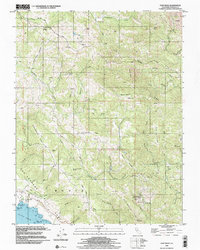
1998 Map of Fort Ross
USGS Topo · Published 2002About this map
Fort Ross State Historic Park anchors this coastal landscape, preserving the site of the southernmost Russian colonial outpost in North America. The map details the complex geological and cultural layering of the Sonoma coast, where the San Andreas Fault Rift Zone carves a distinct northwest-southeast valley parallel to the Pacific shore. This tectonic trench influences the drainage patterns of the Gualala River and creates a dramatic separation between the coastal terrace and the interior ridges.
Find a feature on this map
65 named features on this map. Tap any name to fly to it.
Don’t see what you’re looking for? This feature index may not catch every label — zoom into the map to look around manually.
Map Details
Editions of this 1998 Fort Ross Map
This is the sole edition of this map. No revisions or reprints were ever made.
Other maps of this area

1921 · Skaggs
USGS Topo · 1:62,500

1921 · Plantation
USGS Topo · 1:62,500

1942 · Arched Rock
USGS Topo · 1:24,000

1943 · Tombs Creek
USGS Topo · 1:24,000

1943 · Plantation
USGS Topo · 1:24,000

1943 · Cazadero
USGS Topo · 1:24,000

1943 · Annapolis
USGS Topo · 1:24,000

1943 · Duncans Mills
USGS Topo · 1:24,000

1943 · Skaggs Springs
USGS Topo · 1:24,000

1943 · Fort Ross
USGS Topo · 1:24,000