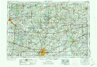
1953 Map of Fort Wayne
USGS Topo · Published 1973About this map
The Maumee River forms at the confluence of the St. Joseph River and St. Marys River in the heart of Fort Wayne, serving as a focal point for this tri-state regional map. During the mid-century, this area saw significant infrastructure expansion, including the development of the Indiana Toll Road and the Ohio Turnpike across the northern corridor. The presence of the Casad Ordnance Depot and Baer Field reflects the era's military and logistical importance. Educational and civic institutions such as Concordia College and the Allen County Courthouse anchor the urban center, while the surrounding landscape is dotted with smaller communities like Churubusco and Ligonier. To the north and west, the terrain is defined by glacial features, including the Tippecanoe River headwaters and numerous lakes protected within Pokagon State Park and Chain O' Lakes State Park.
Find a feature on this map
353 named features on this map. Tap any name to fly to it.
Don’t see what you’re looking for? This feature index may not catch every label — zoom into the map to look around manually.
Map Details
Editions of this 1953 Fort Wayne Map
4 editions found

Other maps of this area

1904 · Ann Arbor
USGS Topo · 1:125,000

1906 · Saline
USGS Topo · 1:62,500

1906 · Columbus Grove
USGS Topo · 1:62,500

1907 · Bluffton
USGS Topo · 1:62,500

1907 · Defiance
USGS Topo · 1:62,500

1908 · Ann Arbor
USGS Topo · 1:125,000

1908 · Columbus Grove
USGS Topo · 1:62,500

1908 · Ottawa
USGS Topo · 1:62,500

1908 · Napoleon
USGS Topo · 1:62,500

1909 · Mc Clure
USGS Topo · 1:62,500