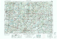
1953 Map of Fort Wayne
USGS Topo · Published 1973About this map
The tri-state convergence of Indiana, Michigan, and Ohio is anchored by Fort Wayne, a critical rail and river hub during the mid-20th century. The landscape is defined by its industrial and military footprint, notably the Casad Ordnance Depot and an extensive network of railroads including the Baltimore and Ohio and New York Central. These lines connect manufacturing centers like Elkhart and Defiance across a terrain marked by glacial remnants such as the Irish Hills and prominent water bodies like Lake Wawasee.
Find a feature on this map
46 named features on this map. Tap any name to fly to it.
Don’t see what you’re looking for? This feature index may not catch every label — zoom into the map to look around manually.
Map Details
Editions of this 1953 Fort Wayne Map
4 editions found

Other maps of this area

1904 · Ann Arbor
USGS Topo · 1:125,000

1906 · Saline
USGS Topo · 1:62,500

1906 · Columbus Grove
USGS Topo · 1:62,500

1907 · Bluffton
USGS Topo · 1:62,500

1907 · Defiance
USGS Topo · 1:62,500

1908 · Ann Arbor
USGS Topo · 1:125,000

1908 · Columbus Grove
USGS Topo · 1:62,500

1908 · Ottawa
USGS Topo · 1:62,500

1908 · Napoleon
USGS Topo · 1:62,500

1909 · Mc Clure
USGS Topo · 1:62,500