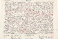
1953 Map of Fort Wayne
USGS Topo · Published 1963About this map
Fort Wayne and its surrounding rail corridors anchor this mid-century survey of the tristate region where Indiana, Michigan, and Ohio meet. The landscape is defined by a dense network of major railroads, including the New York Central, Pennsylvania, and Wabash lines, which served industrial centers like Elkhart, Goshen, and Adrian. This transit infrastructure supported a region of diverse character, from the manufacturing hubs along the Maumee River to the recreational clusters of the glacial lake country. Extensive water systems are documented, featuring Lake Wawasee, Tippecanoe Lake, and Baw Beese Lake. Notable local markers such as Radio Station WOWO and the strangely named Misery Mountain in Michigan provide specific points of interest for local historians. This era reflects the peak of the rail-and-river economy just before the full expansion of the modern interstate system, showing the established hierarchy of towns like Auburn, Coldwater, and Defiance.
Find a feature on this map
37 named features on this map. Tap any name to fly to it.
Don’t see what you’re looking for? This feature index may not catch every label — zoom into the map to look around manually.
Map Details
Editions of this 1953 Fort Wayne Map
4 editions found

Other maps of this area

1904 · Ann Arbor
USGS Topo · 1:125,000

1906 · Saline
USGS Topo · 1:62,500

1906 · Columbus Grove
USGS Topo · 1:62,500

1907 · Bluffton
USGS Topo · 1:62,500

1907 · Defiance
USGS Topo · 1:62,500

1908 · Ann Arbor
USGS Topo · 1:125,000

1908 · Columbus Grove
USGS Topo · 1:62,500

1908 · Ottawa
USGS Topo · 1:62,500

1908 · Napoleon
USGS Topo · 1:62,500

1909 · Mc Clure
USGS Topo · 1:62,500