1994 Map of Fort Wayne
USGS Topo · Published 1994About this map
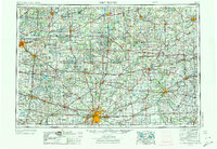
Wawasee Lake and Syracuse Lake anchor the glacial landscape of northeast Indiana, a region defined by its dense network of waterways and early rail corridors. This mid-1990s survey illustrates the complex drainage and recreational geography of Kosciusko, Noble, and Allen counties, where extensive wetland systems are preserved within the Chain O'Lakes State Park and the Tri-County State Fish and Wildlife Area. The map documents the persistent influence of the railroad on local development, showing the Old Ind RR and segments of an Old Railroad Grade near industrial hubs like Nappanee and Kendallville.
Find a feature on this map
155 named features on this map. Tap any name to fly to it.
Don’t see what you’re looking for? This feature index may not catch every label — zoom into the map to look around manually.
Map Details
Editions of this 1994 Fort Wayne Map
This is the sole edition of this map. No revisions or reprints were ever made.
Historical Maps of Fort Wayne Through Time
4 maps found