
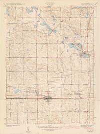
1942 Map of Ashley
USGS Topo · Published 1942About this map
Glacial lakes and intricate drainage systems define this landscape along the Steuben Co De Kalb Co border just before the onset of World War II. The settlement of Ashley sits at a crossroads of the Wabash railroad, which bisects the southern half of the map, and the north-south lines of the Central York New system. This rail junction, alongside the neighboring town of Hudson, highlights the region's historical role as a transit and agricultural hub. To the north, the terrain is dominated by a dense concentration of water bodies including Golden Lake, Silver Lake, and Long Lake, many of which are connected by Pigeon Creek or man-made channels like Johnson Ditch. Local history is preserved through numerous family and community landmarks, such as Hollister Cem, Mt Zion Ch, and the Old Gravel Pit near the village of Pleasant Lake, providing a clear picture of rural life in Indiana at this time.
Find a feature on this map
45 named features on this map. Tap any name to fly to it.
Don’t see what you’re looking for? This feature index may not catch every label — zoom into the map to look around manually.
Map Details
Editions of this 1942 Ashley Map
2 editions found
Other maps of this area

1939 · Hamilton
USGS Topo · 1:24,000

1939 · Angola East
USGS Topo · 1:24,000

1940 · Orland
USGS Topo · 1:24,000

1941 · Orland
USGS Topo · 1:24,000

1941 · Angola West
USGS Topo · 1:24,000

1942 · Angola West
USGS Topo · 1:24,000

1942 · Stroh
USGS Topo · 1:24,000

1947 · Angola East
USGS Topo · 1:24,000

1948 · Hamilton
USGS Topo · 1:24,000

1953 · Fort Wayne
USGS Topo · 1:250,000