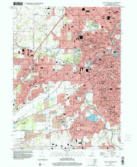
1998 Map of Fort Wayne West
USGS Topo · Published 2001About this map
St Marys River and the Maumee River converge in this western portion of the city, where mid-century suburban expansion met established institutional landmarks. The landscape is dense with educational and religious history, featuring St Francis College, the Fort Wayne Bible College, and several parochial schools such as Bethlehem Sch and Queen of Angels Sch. The infrastructure of the era is evident in the burgeoning residential developments of Country Club Gardens and Indian Village, alongside significant public spaces like Lindenwood Cemetery and the Johnny Appleseed Memorial Park. The Norfolk and Western railway lines and the southern passage of the Little River define the industrial and natural borders of the city as it grew toward Waynedale and the western townships.
Find a feature on this map
101 named features on this map. Tap any name to fly to it.
Don’t see what you’re looking for? This feature index may not catch every label — zoom into the map to look around manually.
Map Details
Editions of this 1998 Fort Wayne West Map
This is the sole edition of this map. No revisions or reprints were ever made.
Other maps of this area

1953 · Fort Wayne
USGS Topo · 1:250,000

1953 · Muncie
USGS Topo · 1:250,000

1956 · Muncie
USGS Topo · 1:250,000

1956 · Fort Wayne
USGS Topo · 1:250,000

1956 · Fort Wayne West
USGS Topo · 1:24,000

1956 · Fort Wayne East
USGS Topo · 1:24,000

1956 · Cedarville
USGS Topo · 1:24,000

1957 · Huntertown
USGS Topo · 1:24,000

1957 · Churubusco
USGS Topo · 1:24,000

1961 · Arcola
USGS Topo · 1:24,000
Featured Places
- Fort Wayne, IN
- Indian Village, Fort Wayne
- Northcrest, Fort Wayne
- Ansley Acres, IN
- Westchester, Fort Wayne