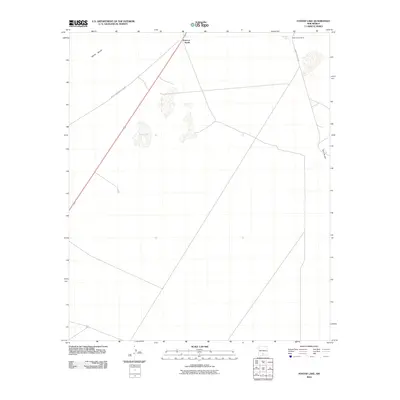
2010 Map of Foster Lake
USGS Topo · Published 2010About this map
White Sands Missile Range dominates this high-desert landscape in Otero County, where modern military installations meet the ancient geology of the White Sands region. The topography is defined by sparse but significant water sources and ranching outposts, including Harrington Spring and the White Sands Ranch located in the northeast. The presence of Foster Lake and several smaller unnamed basins illustrate the ephemeral drainage patterns characteristic of the Tularosa Basin. Human activity is largely funneled along WSMR S Route 260, connecting the isolated Point of Sands to the broader restricted range. Prominent landforms such as Twin Buttes provide essential navigational landmarks across this wide, open terrain, highlighting the intersection of mid-20th-century defense infrastructure and traditional Southwestern land use.
Find a feature on this map
8 named features on this map. Tap any name to fly to it.
Don’t see what you’re looking for? This feature index may not catch every label — zoom into the map to look around manually.
Map Details
Editions of this 2010 Foster Lake Map
This is the sole edition of this map. No revisions or reprints were ever made.
Other maps of this area

1916 · Point Of Sands
USGS Topo · 1:125,000

1947 · Point Of Sands 2
USGS Topo · 1:62,500

1947 · Lake Lucero
USGS Topo · 1:62,500

1948 · Tres Hermanos
USGS Topo · 1:62,500

1948 · Holloman
USGS Topo · 1:62,500

1948 · Lake Lucero SE
USGS Topo · 1:24,000
1950 · Lake Lucero SE
USGS Topo · 1:24,000
1950 · Lake Lucero NE
USGS Topo · 1:24,000

1955 · Las Cruces
USGS Topo · 1:250,000

1958 · Las Cruces
USGS Topo · 1:250,000