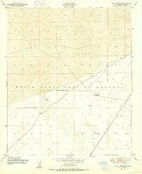
1950 Map of Lake Lucero NE
USGS Topo · Published 1950About this map
White Sands National Monument and the surrounding White Sands Proving Grounds dominate this 1950 topographic survey, capturing a high-desert landscape defined by vast gypsum dunes and military expansion. The map records the early overlap of civilian ranching and federal defense land use in the Tularosa Basin, showing Bairds Ranch and its associated Windmills near the National Monument Boundary. These small outposts of human habitation and water sources like Antelope Tank represent the precarious nature of life in the White Sands region during the mid-century transition. The survey reflects a moment when the Department of the Army and the Department of the Interior managed adjacent tracts of this distinct geological environment, just before the full enclosure of many historic ranching holdings for missile testing operations.
Find a feature on this map
9 named features on this map. Tap any name to fly to it.
Don’t see what you’re looking for? This feature index may not catch every label — zoom into the map to look around manually.
Map Details
Editions of this 1950 Lake Lucero NE Map
This is the sole edition of this map. No revisions or reprints were ever made.
Other maps of this area

1916 · Point Of Sands
USGS Topo · 1:125,000

1947 · Point Of Sands 2
USGS Topo · 1:62,500

1947 · Lake Lucero
USGS Topo · 1:62,500

1948 · Tres Hermanos
USGS Topo · 1:62,500

1948 · Holloman
USGS Topo · 1:62,500

1948 · Lake Lucero
USGS Topo · 1:24,000

1948 · Lake Lucero SW
USGS Topo · 1:24,000

1948 · Lake Lucero SE
USGS Topo · 1:24,000
1950 · Lake Lucero
USGS Topo · 1:24,000
1950 · Lake Lucero SW
USGS Topo · 1:24,000