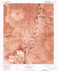
1981 Map of Foster Well
USGS Topo · Published 1981About this map
White Sands Missile Range dominates this orthophotomap of the Socorro County desert, capturing the land as it appeared in the early 1980s. The aerial imagery reveals a landscape of tactical infrastructure and livestock management, where an Observation Tower and Heliport stand in proximity to traditional water sources like Foster Well and Lewis Well. This specific terrain illustrates the overlapping uses of the New Mexico high desert, where military testing grounds and ranching relics exist side-by-side. Evidence of industrial or exploratory activity is marked by Borrow Pits and Drill Holes, while the arid surface is punctuated by catchment basins such as Pole Russell Tank and Lewis Tank. A single Trail is visible, cutting through the basin and range province near the Pond Site, providing a record of the limited transportation network within this restricted military zone.
Find a feature on this map
14 named features on this map. Tap any name to fly to it.
Don’t see what you’re looking for? This feature index may not catch every label — zoom into the map to look around manually.
Map Details
Editions of this 1981 Foster Well Map
2 editions found
Other maps of this area

1916 · Salinas Peak
USGS Topo · 1:125,000

1916 · Tularosa
USGS Topo · 1:125,000

1918 · Oscura Peak
USGS Topo · 1:125,000

1947 · Capitol Peak
USGS Topo · 1:62,500

1948 · Granjean Well
USGS Topo · 1:62,500

1948 · Mockingbird Gap
USGS Topo · 1:62,500

1948 · Salinas Peak
USGS Topo · 1:62,500

1954 · Tularosa
USGS Topo · 1:250,000

1958 · Tularosa
USGS Topo · 1:250,000

1981 · Fairview Mountain
USGS Topo · 1:24,000