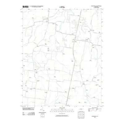
2010 Map of Fosterville
USGS Topo · Published 2010About this map
Fosterville and the surrounding rural landscapes of Rutherford County are defined by a dense network of family-named cemeteries and quiet crossroads. This 2010 survey reveals a deeply rooted community structure, where the West Fork Stones River and its tributaries like Panther Creek and Dry Fork Creek snake through terrain punctuated by distinctive heights such as Nebo Knobs and Soapstone Hill. The settlement pattern is anchored by the Christiana Post Office and the Fosterville Post Office, serving a region where local geography is often marked by family legacies.
Find a feature on this map
96 named features on this map. Tap any name to fly to it.
Don’t see what you’re looking for? This feature index may not catch every label — zoom into the map to look around manually.
Map Details
Editions of this 2010 Fosterville Map
This is the sole edition of this map. No revisions or reprints were ever made.
Other maps of this area

1916 · Murfreesboro
USGS Topo · 1:62,500

1936 · Webbs Jungle
USGS Topo · 1:24,000

1936 · Rover
USGS Topo · 1:24,000

1936 · Deason
USGS Topo · 1:24,000

1936 · Wartrace
USGS Topo · 1:24,000

1936 · Unionville
USGS Topo · 1:24,000

1936 · Fosterville
USGS Topo · 1:24,000

1942 · Lebanon
USGS Topo · 1:100,000

1944 · Shelbyville
USGS Topo · 1:100,000
1947 · Unionville
USGS Topo · 1:24,000