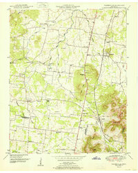
1951 Map of Fosterville
USGS Topo · Published 1951About this map
Fosterville and Christiana anchor this mid-century portrait of the Tennessee countryside along the Nashville Chattanooga and St Louis railroad line. The landscape is defined by the Tennessee Valley Divide, which separates the headwaters of the Stones River from the North Fork Creek drainage. This survey, based on 1940s aerial photography, reveals a dense network of rural community centers, each marked by family-named landmarks and local institutions. Genealogists will find a wealth of specific locations such as Alexander Cem, Spence Cem, and Morgan Cem. The topographic detail highlights the transition from the relatively level agricultural lands in the west to the more prominent elevations of Nebo Knobs, Hickory Hill, and Soapstone Hill in the southeast. Cultural hubs like Midland Sch and Guy Gap Sch suggest the localized nature of education and social life before the era of widespread school consolidation.
Find a feature on this map
49 named features on this map. Tap any name to fly to it.
Don’t see what you’re looking for? This feature index may not catch every label — zoom into the map to look around manually.
Map Details
Editions of this 1951 Fosterville Map
2 editions found
Other maps of this area

1916 · Murfreesboro
USGS Topo · 1:62,500

1936 · Webbs Jungle
USGS Topo · 1:24,000

1936 · Rover
USGS Topo · 1:24,000

1936 · Deason
USGS Topo · 1:24,000

1936 · Wartrace
USGS Topo · 1:24,000

1936 · Unionville
USGS Topo · 1:24,000

1936 · Fosterville
USGS Topo · 1:24,000

1942 · Lebanon
USGS Topo · 1:100,000

1944 · Shelbyville
USGS Topo · 1:100,000
1947 · Unionville
USGS Topo · 1:24,000