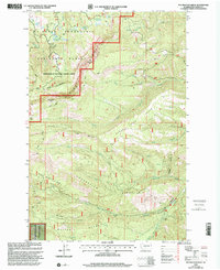
2000 Map of Foundation Ridge
USGS Topo · Published 2001About this map
Foundation Ridge and the Whites Ridge highlands define this portion of the Yakima area, where the Mt Baker-Snoqualmie National Forest meets land administered by the Wenatchee National Forest. The landscape is characterized by high-elevation meadows and peaks, including Pickle Prairie Meadows near the northern boundary and the prominence of Strobach Mtn and Dome Peak. Human presence is concentrated around the Ahtanum Guard Sta and the drainage of Ahtanum Creek, which serves as a primary water source for the southern portion of the quadrangle.
Find a feature on this map
40 named features on this map. Tap any name to fly to it.
Don’t see what you’re looking for? This feature index may not catch every label — zoom into the map to look around manually.
Map Details
Editions of this 2000 Foundation Ridge Map
This is the sole edition of this map. No revisions or reprints were ever made.
Other maps of this area

1899 · Ellensburg
USGS Topo · 1:125,000

1901 · Ellensburg
USGS Topo · 1:125,000

1902 · Mount Aix
USGS Topo · 1:125,000

1904 · Mt Aix
USGS Topo · 1:125,000

1904 · Mount Adams
USGS Topo · 1:125,000

1907 · Mount Adams
USGS Topo · 1:125,000

1937 · White Swan
USGS Topo · 1:125,000

1950 · Yakima
USGS Topo · 1:250,000

1957 · Yesmowit Canyon
USGS Topo · 1:24,000

1958 · Fort Simcoe
USGS Topo · 1:62,500