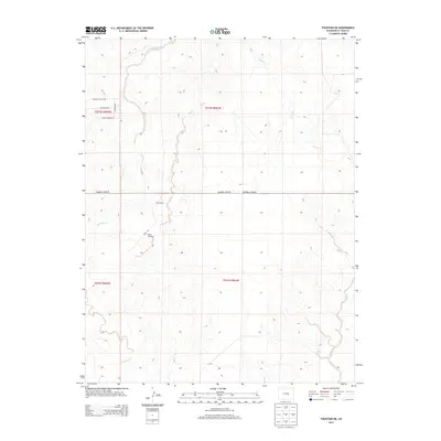
2013 Map of Fountain NE
USGS Topo · Published 2013About this map
Kane Ranch stands as a focal point in this eastern El Paso County landscape, where the high plains meeting the drainage systems of Williams Creek and Chico Cr. The terrain is characterized by the repeated north-south incisions of these waterways, which dictate the placement of ranch infrastructure and local roads. Practical features like the Bailey Windmill suggest the reliance on groundwater in this arid environment east of the Front Range. The layout of the road network, including Peaceful Valley Rd and Squirrel Creek Rd, follows the section lines of the Public Land Survey System, illustrating the orderly division of the land into townships such as t015s r064w. This 2013 survey provides a clear view of the low-density rural character and ranching legacy that persists on the outskirts of the growing Colorado Springs metropolitan area.
Find a feature on this map
16 named features on this map. Tap any name to fly to it.
Don’t see what you’re looking for? This feature index may not catch every label — zoom into the map to look around manually.
Map Details
Editions of this 2013 Fountain NE Map
This is the sole edition of this map. No revisions or reprints were ever made.
Other maps of this area

1893 · Big Springs
USGS Topo · 1:125,000

1893 · Colorado Springs
USGS Topo · 1:125,000

1909 · Colorado Springs
USGS Topo · 1:125,000

1942 · Colorado Springs
USGS Topo · 1:125,000

1948 · Fountain SE
USGS Topo · 1:24,000

1948 · Fountain
USGS Topo · 1:24,000

1948 · Falcon
USGS Topo · 1:62,500
1949 · Buttes
USGS Topo · 1:24,000

1949 · Corral Bluffs
USGS Topo · 1:24,000
1950 · Elsmere
USGS Topo · 1:24,000