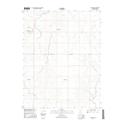
2016 Map of Fountain NE
USGS Topo · Published 2016About this map
Williams Creek and Chico Cr define the drainage patterns across this El Paso County landscape, carving through the high plains east of Fountain. The map reveals a transition in land use, where a nascent network of residential roads like Peaceful Valley Rd and Raintree Dr in the northwest corner gives way to the large-scale grid of the Public Land Survey System. The presence of Grassland Rd and Green Spring Rd suggests the early stages of rural development in an area otherwise dominated by open range and ephemeral watercourses. Researchers can trace the path of Squirrel Creek Rd as it traverses the center of the quadrangle, serving as a primary east-west corridor through the township sections of T15S and T16S.
Find a feature on this map
12 named features on this map. Tap any name to fly to it.
Don’t see what you’re looking for? This feature index may not catch every label — zoom into the map to look around manually.
Map Details
Editions of this 2016 Fountain NE Map
This is the sole edition of this map. No revisions or reprints were ever made.
Other maps of this area

1893 · Big Springs
USGS Topo · 1:125,000

1893 · Colorado Springs
USGS Topo · 1:125,000

1909 · Colorado Springs
USGS Topo · 1:125,000

1942 · Colorado Springs
USGS Topo · 1:125,000

1948 · Fountain SE
USGS Topo · 1:24,000

1948 · Fountain
USGS Topo · 1:24,000

1948 · Falcon
USGS Topo · 1:62,500
1949 · Buttes
USGS Topo · 1:24,000

1949 · Corral Bluffs
USGS Topo · 1:24,000
1950 · Elsmere
USGS Topo · 1:24,000