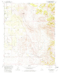
1965 Map of Fountain Springs
USGS Topo · Published 1982About this map
Fountain Springs and the surrounding Tulare County landscape reflect a mid-century transition from agricultural valley floor to the prominent rising terrain of Tennessee Ridge. The western edge of the map follows the Atchison Topeka and Santa Fe railroad line, which served the small settlements of Ultra and Deer Creek Colony. A network of numbered avenues, from Avenue 108 down to Avenue 56, reveals a structured grid of rural property lines and small-scale ranching operations, such as Dennis Ranch.
Find a feature on this map
28 named features on this map. Tap any name to fly to it.
Don’t see what you’re looking for? This feature index may not catch every label — zoom into the map to look around manually.
Map Details
Editions of this 1965 Fountain Springs Map
4 editions found
Other maps of this area

1904 · Kaweah
USGS Topo · 1:125,000

1909 · Kaweah
USGS Topo · 1:125,000

1926 · Quincy School
USGS Topo · 1:31,680

1929 · Richgrove
USGS Topo · 1:31,680

1929 · Porterville
USGS Topo · 1:31,680

1929 · Quincy School
USGS Topo · 1:31,680

1929 · Ducor
USGS Topo · 1:31,680

1936 · White River
USGS Topo · 1:62,500

1936 · Tobias Peak
USGS Topo · 1:125,000

1937 · Kaweah
USGS Topo · 1:125,000