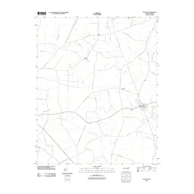
2010 Map of Fountain
USGS Topo · Published 2010About this map
The town of Fountain and its surrounding Pitt County farmsteads are documented in this 2010 survey, which highlights a landscape defined by the winding Little Contentnea Creek and its many tributaries. The area maintains a rural, agricultural character, with smaller settlements like Webbs, Turnage, and Toddy connected by a network of state routes and county roads. Near the center of Fountain, the Fountain Post Office and Memorial Cemetery serve as local landmarks for genealogists and town residents.
Find a feature on this map
61 named features on this map. Tap any name to fly to it.
Don’t see what you’re looking for? This feature index may not catch every label — zoom into the map to look around manually.
Map Details
Editions of this 2010 Fountain Map
This is the sole edition of this map. No revisions or reprints were ever made.
Other maps of this area

1902 · Rocky Mount
USGS Topo · 1:62,500

1902 · Tarboro
USGS Topo · 1:62,500

1903 · Tarboro
USGS Topo · 1:62,500

1904 · Falkland
USGS Topo · 1:62,500

1904 · Rocky Mount
USGS Topo · 1:62,500

1904 · Wilson
USGS Topo · 1:62,500

1953 · Rocky Mount
USGS Topo · 1:250,000

1954 · Rocky Mount
USGS Topo · 1:250,000
1977 · Elm City
USGS Topo · 1:24,000
1978 · Stantonsburg
USGS Topo · 1:24,000