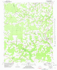
1981 Map of Fountain
USGS Topo · Published 1982About this map
Fountain stands at the eastern edge of a landscape defined by its intricate waterways and rural heritage, documented here just after the late 1970s. The terrain is marked by the sprawling The Pocosin to the west and the convergence of Otter Creek, Little Contentnea Creek, and Ward Run. These watercourses dictated the early settlement patterns of the region, where numerous family-centered landmarks like Webbtown Ch and Webbs Chapel appear alongside the small communities of Macclesfield, Crisp, and Toddy.
Find a feature on this map
32 named features on this map. Tap any name to fly to it.
Don’t see what you’re looking for? This feature index may not catch every label — zoom into the map to look around manually.
Map Details
Editions of this 1981 Fountain Map
This is the sole edition of this map. No revisions or reprints were ever made.
Other maps of this area

1902 · Rocky Mount
USGS Topo · 1:62,500

1902 · Tarboro
USGS Topo · 1:62,500

1903 · Tarboro
USGS Topo · 1:62,500

1904 · Falkland
USGS Topo · 1:62,500

1904 · Rocky Mount
USGS Topo · 1:62,500

1904 · Wilson
USGS Topo · 1:62,500

1953 · Rocky Mount
USGS Topo · 1:250,000

1954 · Rocky Mount
USGS Topo · 1:250,000
1977 · Elm City
USGS Topo · 1:24,000
1978 · Stantonsburg
USGS Topo · 1:24,000