
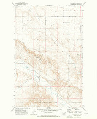
1973 Map of Four Buttes
USGS Topo · Published 1976About this map
Four Buttes sits at the heart of this Montana landscape, where the Burlington Northern railroad cuts a straight east-west line across the prairie. The settlement is defined by its relation to the rail line and the nearby watercourses that carve through the plains, including the winding Butte Creek and its various tributaries. The map captures a moment in the mid-1970s when the region's agricultural and industrial character was marked by numerous Storage Bins, a prominent Radio Tower, and an isolated Oil Well to the northwest. Land use is further illustrated by the fine network of fence lines and coulees like Audet Coulee and La Pierre Coulee, which dictate the movement across the undulating terrain north of the railroad tracks.
Find a feature on this map
12 named features on this map. Tap any name to fly to it.
Don’t see what you’re looking for? This feature index may not catch every label — zoom into the map to look around manually.
Map Details
Editions of this 1973 Four Buttes Map
This is the sole edition of this map. No revisions or reprints were ever made.
Other maps of this area

1954 · Wolf Point
USGS Topo · 1:250,000

1958 · Wolf Point
USGS Topo · 1:250,000

1973 · Peerless 4 NE
USGS Topo · 1:24,000

1973 · Scobey
USGS Topo · 1:24,000

1973 · Scobey NW
USGS Topo · 1:24,000

1973 · Killenbeck Reservoir
USGS Topo · 1:24,000

1973 · Cabarett Coulee
USGS Topo · 1:24,000

1973 · Four Buttes NE
USGS Topo · 1:24,000

1973 · Four Buttes NW
USGS Topo · 1:24,000
1973 · Peerless 4 NW
USGS Topo · 1:24,000