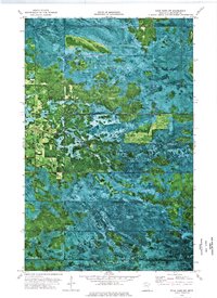
1973 Map of Four Town NW
USGS Topo · Published 1976About this map
The Moose River winds through this orthophotomap of Beltrami County, marking a distinct transition between the wetlands of the Beltrami Island State Forest and the northern reaches of the Red Lake Indian Reservation. This 1973 survey, built from 1969 aerial photography, provides a literal look at the hydrology and vegetation patterns of the region. The map reveals the functional landscape of the era, where a network of Winter Trails and secondary paths provided access through the low-lying terrain. To the southwest, the Northwood State Wildlife Management Area occupies a significant portion of the landscape, illustrating the conservation and land-management priorities in Northern Minnesota during the early 1970s. The mix of photographic imagery and topographic contours offers a rare view of how roads and natural drainage systems interact within these protected forest and tribal lands.
Find a feature on this map
10 named features on this map. Tap any name to fly to it.
Don’t see what you’re looking for? This feature index may not catch every label — zoom into the map to look around manually.
Map Details
Editions of this 1973 Four Town NW Map
This is the sole edition of this map. No revisions or reprints were ever made.
Other maps of this area

1918 · Pencer
USGS Topo · 1:62,500

1918 · Malcolm
USGS Topo · 1:62,500

1919 · Liner
USGS Topo · 1:62,500

1954 · Roseau
USGS Topo · 1:250,000

1957 · Roseau
USGS Topo · 1:250,000

1958 · Roseau
USGS Topo · 1:250,000

1968 · Mulligan Lake SW
USGS Topo · 1:24,000
1968 · Mulligan Lake
USGS Topo · 1:24,000
1969 · Skime
USGS Topo · 1:24,000

1973 · Gates Corner
USGS Topo · 1:24,000