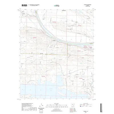
2020 Map of Fourche
USGS Topo · Published 2020About this map
The Arkansas River and its broad bottomlands dominate this 2020 landscape, marking the intersection of Faulkner, Pulaski, and Perry counties. To the south, the terrain rises into the foothills where Little Italy sits along the ridge, flanked by prominent elevations like Kryer Mtn and Moss Mtn. This area reflects a deep-rooted cultural geography, evidenced by small rural settlements and a network of family-associated cemeteries such as Saint Francis Cem, Faisst Cem, and Rainey Cem.
Find a feature on this map
88 named features on this map. Tap any name to fly to it.
Don’t see what you’re looking for? This feature index may not catch every label — zoom into the map to look around manually.
Map Details
Editions of this 2020 Fourche Map
This is the sole edition of this map. No revisions or reprints were ever made.
Other maps of this area

1890 · Benton
USGS Topo · 1:125,000

1891 · Little Rock
USGS Topo · 1:125,000

1892 · Morrillton
USGS Topo · 1:125,000

1893 · Little Rock
USGS Topo · 1:125,000

1894 · Morrillton
USGS Topo · 1:125,000

1894 · Benton
USGS Topo · 1:125,000

1943 · Pinnacle Mtn
USGS Topo · 1:31,680

1953 · Mayflower
USGS Topo · 1:24,000
1954 · Pinnacle Mountain
USGS Topo · 1:24,000

1955 · Little Rock
USGS Topo · 1:250,000