
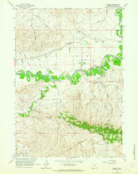
1961 Map of Fourmile Reservoir
USGS Topo · Published 1964About this map
The Reno Hill Anticline dominates the central landscape of this Johnson County survey, illustrating the complex geologic folds that define the region's topography. Water management in this arid environment is anchored by the Fourmile Reservoir, which collects drainage from the North Fork Fourmile Creek and Fourmile Creek. The land is segmented by numerous seasonal draws, including Pheasant Draw, Truk Draw, and Voelkner Draw, which provide crucial drainage during the spring thaw and storm events. Scattered evidence of human activity is visible through a remote Cem and a marked Corral, suggesting the area's legacy as rangeland. The presence of the Buffalo Sussex Cutoff indicates established transportation routes through the foothills, while several Well markers point to early resource exploration and water access for livestock near Reno Hill.
Find a feature on this map
18 named features on this map. Tap any name to fly to it.
Don’t see what you’re looking for? This feature index may not catch every label — zoom into the map to look around manually.
Map Details
Editions of this 1961 Fourmile Reservoir Map
This is the sole edition of this map. No revisions or reprints were ever made.
Other maps of this area

1955 · Arminto
USGS Topo · 1:250,000

1958 · Arminto
USGS Topo · 1:250,000

1961 · Soldier Creek
USGS Topo · 1:24,000

1961 · Kaycee NE
USGS Topo · 1:24,000

1961 · Figure 8 Reservoir
USGS Topo · 1:24,000

1961 · Dry Creek Reservoir
USGS Topo · 1:24,000

1961 · Antelope Draw
USGS Topo · 1:24,000

1961 · Provence Ranch
USGS Topo · 1:24,000

1961 · Elaine Draw
USGS Topo · 1:24,000
1961 · Sussex
USGS Topo · 1:24,000