
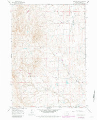
1961 Map of Antelope Draw
USGS Topo · Published 1964About this map
Dry Creek Basin dominates the upper reaches of this Johnson County landscape, where the high plains of Wyoming are etched by an intricate network of seasonal drainages. During this early 1960s survey, the area maintained a quiet, ranching-focused character centered around the Crain Ranch and the nearby Crain Sch. The topography is defined by significant elevations such as Reno Hill, which overlooks the descent toward Antelope Draw and Cathers Draw. The drainage patterns, including the West Fork and Trabing Creek, suggest a landscape shaped by intermittent water flow typical of the region's arid climate. Evidence of industrial exploration appears sparingly, marked by a single Drill Hole in the northwest, indicating the early stages of mineral or geological surveying in this part of the county.
Find a feature on this map
13 named features on this map. Tap any name to fly to it.
Don’t see what you’re looking for? This feature index may not catch every label — zoom into the map to look around manually.
Map Details
Editions of this 1961 Antelope Draw Map
2 editions found
Other maps of this area

1900 · Fort McKinney
USGS Topo · 1:125,000

1903 · Fort McKinney
USGS Topo · 1:125,000

1955 · Sheridan
USGS Topo · 1:250,000

1955 · Arminto
USGS Topo · 1:250,000

1958 · Sheridan
USGS Topo · 1:250,000

1958 · Arminto
USGS Topo · 1:250,000

1961 · Fourmile Reservoir
USGS Topo · 1:24,000

1961 · Dry Creek Reservoir
USGS Topo · 1:24,000

1961 · Schlict Draw
USGS Topo · 1:24,000

1961 · Elaine Draw
USGS Topo · 1:24,000