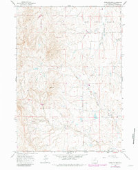
1961 Map of Antelope Draw
USGS Topo · Published 1982About this map
Reno Hill stands as a prominent topographical landmark in this high plains region of Johnson County, overlooking a network of seasonal watercourses and ranching operations. The landscape is defined by the Dry Creek Basin and the winding paths of Antelope Draw and Ninemile Creek. Settled life is centered around the Crain Ranch and the nearby Crain Sch, reflecting the importance of rural education and family-held livestock operations in this era of Wyoming history. Transportation is facilitated by the Buffalo Sussex Cutoff, which connects the area's remote drainages like Trabing Creek and Cathers Draw. This survey captures the spatial relationship between isolated homesteads and the vast, arid terrain during the mid-20th century before significant modern development altered the land use patterns.
Find a feature on this map
14 named features on this map. Tap any name to fly to it.
Don’t see what you’re looking for? This feature index may not catch every label — zoom into the map to look around manually.
Map Details
Editions of this 1961 Antelope Draw Map
2 editions found
Other maps of this area

1900 · Fort McKinney
USGS Topo · 1:125,000

1903 · Fort McKinney
USGS Topo · 1:125,000

1955 · Sheridan
USGS Topo · 1:250,000

1955 · Arminto
USGS Topo · 1:250,000

1958 · Sheridan
USGS Topo · 1:250,000

1958 · Arminto
USGS Topo · 1:250,000

1961 · Fourmile Reservoir
USGS Topo · 1:24,000

1961 · Dry Creek Reservoir
USGS Topo · 1:24,000

1961 · Antelope Draw
USGS Topo · 1:24,000

1961 · Schlict Draw
USGS Topo · 1:24,000