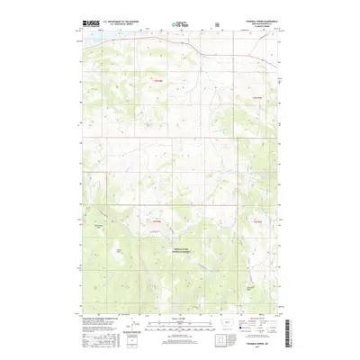
2017 Map of Fourmile Spring
USGS Topo · Published 2017About this map
Lewis & Clark National Forest encompasses the southern portion of this landscape, where the terrain rises toward the prominent Limestone Ridge. This 2017 survey details a high-elevation watershed defined by numerous named water sources, including Lake Sutherlin in the northwest and a network of springs such as Fourmile Spring, Bair Spring, and Hall Creek Spring. The presence of large open clearings like Richardson Park and Horse Park among the timbered slopes suggests long-standing use for grazing or recreation. Transportation in the area is limited to rugged routes like Jamison Trail Rd and Fourmile Creek Rd, which provide access to the drainages of Fivemile Cr and Checkerboard Cr.
Find a feature on this map
29 named features on this map. Tap any name to fly to it.
Don’t see what you’re looking for? This feature index may not catch every label — zoom into the map to look around manually.
Map Details
Editions of this 2017 Fourmile Spring Map
This is the sole edition of this map. No revisions or reprints were ever made.
Other maps of this area

1886 · Little Belt Mts.
USGS Topo · 1:250,000

1894 · Little Belt Mts.
USGS Topo · 1:250,000

1897 · Little Belt Mts.
USGS Topo · 1:250,000

1898 · Little Belt Mts.
USGS Topo · 1:250,000

1902 · Little Belt Mts.
USGS Topo · 1:250,000

1948 · White Sulphur Springs
USGS Topo · 1:250,000

1958 · White Sulphur Springs
USGS Topo · 1:250,000

1961 · White Sulphur Springs
USGS Topo · 1:250,000

1965 · White Sulphur Springs
USGS Topo · 1:250,000
1971 · Charcoal Gulch
USGS Topo · 1:24,000