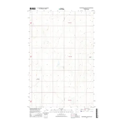
2017 Map of Fourteenmile Coulee NW
USGS Topo · Published 2017About this map
The East Fork Black Coulee drainage system dominates the landscape of this portion of Hill County, where the high plains are etched by deep coulees and seasonal watercourses. Situated in the heart of the Montana Big Sky country, the terrain is defined by its vast agricultural utility and the natural drainage patterns that have shaped its settlement. The map reveals a highly structured environment organized by the Public Land Survey System, with township lines such as t31n r10e and t32n r9e clearly delineating the vast ranchlands. Local infrastructure is primarily limited to secondary rural routes like Hingham Rd and Highland Rd S, which facilitate access to the remote fields and water sources. To the east, the sharp descent of Faulkners Coulee provides a stark contrast to the flatter upland plains, illustrating the erosion-carved topography characteristic of this region.
Find a feature on this map
11 named features on this map. Tap any name to fly to it.
Don’t see what you’re looking for? This feature index may not catch every label — zoom into the map to look around manually.
Map Details
Editions of this 2017 Fourteenmile Coulee NW Map
This is the sole edition of this map. No revisions or reprints were ever made.
Other maps of this area

1919 · Big Sandy
USGS Topo · 1:125,000

1919 · Alma
USGS Topo · 1:125,000

1920 · Gildford
USGS Topo · 1:125,000

1943 · Gildford
USGS Topo · 1:125,000

1954 · Shelby
USGS Topo · 1:250,000

1958 · Shelby
USGS Topo · 1:250,000

1969 · Fourteenmile Coulee SW
USGS Topo · 1:24,000

1969 · Hingham
USGS Topo · 1:24,000

1969 · Fourteenmile Coulee NW
USGS Topo · 1:24,000
1969 · Fourteenmile Coulee SE
USGS Topo · 1:24,000