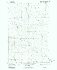
1967 Map of Fowler Coulee NW
USGS Topo · Published 1985About this map
Pondera Coulee and its winding tributaries dominate this High Plains landscape, where the drainage patterns of Fowler Coulee and Favot Coulee carve through the open terrain. The map captures a section of the northern Montana plains during the mid-1960s, defined by the intersection of the Principal Meridian and the county boundary between Pondera and Toole counties.
Find a feature on this map
9 named features on this map. Tap any name to fly to it.
Don’t see what you’re looking for? This feature index may not catch every label — zoom into the map to look around manually.
Map Details
Editions of this 1967 Fowler Coulee NW Map
2 editions found
Other maps of this area

1920 · Conrad
USGS Topo · 1:125,000

1954 · Shelby
USGS Topo · 1:250,000

1958 · Shelby
USGS Topo · 1:250,000

1967 · Central School
USGS Topo · 1:24,000

1967 · Conrad Butte
USGS Topo · 1:24,000

1967 · Brady
USGS Topo · 1:24,000

1967 · Fowler Coulee SW
USGS Topo · 1:24,000

1967 · Fowler Coulee NW
USGS Topo · 1:24,000
1967 · Letz Lake
USGS Topo · 1:24,000
1967 · Fowler Coulee SE
USGS Topo · 1:24,000