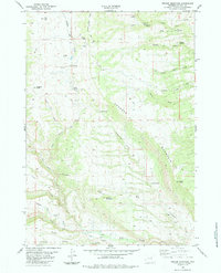
1984 Map of Fraker Mountain
USGS Topo · Published 1984About this map
Fraker Mountain and the towering Gardner Mountain anchor this landscape in Johnson County, surveyed in the late 1970s. The topography is defined by intricate drainage systems and high-altitude landmarks, including the natural formations of The Arch and The Crevasses. Human activity is sparse but distinct, marked by the Stone Corrals in the north and the irrigation infrastructure of the Red Wall Ditch near the Powder River in the south. The area’s complex geology is evident in features like Snow Cave Ridge and the Ice Cave. Long-established backcountry routes such as the Mayworth Slope Road and The Slip Road provide access across the high ridges, connecting localized landmarks like Gobblers Knob and Bald Knob with the seasonal waters of Cottonwood Creek.
Find a feature on this map
45 named features on this map. Tap any name to fly to it.
Don’t see what you’re looking for? This feature index may not catch every label — zoom into the map to look around manually.
Map Details
Editions of this 1984 Fraker Mountain Map
This is the sole edition of this map. No revisions or reprints were ever made.
Other maps of this area

1955 · Arminto
USGS Topo · 1:250,000

1958 · Arminto
USGS Topo · 1:250,000

1961 · Barnum
USGS Topo · 1:62,500

1962 · Arminto
USGS Topo · 1:250,000

1963 · Mayoworth
USGS Topo · 1:62,500
1967 · Beartrap Meadows
USGS Topo · 1:24,000
1967 · Tabletop
USGS Topo · 1:24,000

1967 · Turk Springs
USGS Topo · 1:24,000
1979 · Red Fork Powder River
USGS Topo · 1:24,000
1979 · Nowater Creek
USGS Topo · 1:100,000