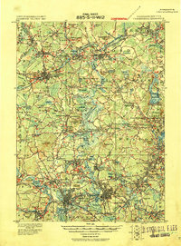
1918 Map of Framingham
USGS Topo · Published 1918About this map
The Assabet River and Sudbury River converge near Concord, forming a landscape defined by expansive marshes like the Sedge Meadows and numerous glacial ponds. This 1918 progressive military sheet, compiled under Col. W. M. Black, reveals a sophisticated early 20th-century transportation network where the Fitchburg Railroad and Central Massachusetts lines intersect historic post-road landmarks like the Wayside Inn. The presence of the State Reformatory near Westvale and the State Prison in South Framingham highlights the institutional character of the era's regional planning.
Find a feature on this map
153 named features on this map. Tap any name to fly to it.
Don’t see what you’re looking for? This feature index may not catch every label — zoom into the map to look around manually.
Map Details
Editions of this 1918 Framingham Map
2 editions found
Other maps of this area

1886 · Lawrence
USGS Topo · 1:62,500

1886 · Blackstone
USGS Topo · 1:62,500

1886 · Dedham
USGS Topo · 1:62,500

1886 · Lowell
USGS Topo · 1:62,500

1886 · Framingham
USGS Topo · 1:62,500

1887 · Franklin
USGS Topo · 1:62,500

1887 · Marlboro
USGS Topo · 1:62,500

1888 · Lawrence
USGS Topo · 1:62,500

1889 · Marlboro
USGS Topo · 1:62,500

1889 · Blackstone
USGS Topo · 1:62,500