
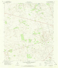
1971 Map of Frankel City
USGS Topo · Published 1974About this map
The Fullerton Oil Field dominates this West Texas landscape, showing a complex industrial network of the early 1970s. The map illustrates an economy built on energy extraction, with a dense web of a Pipeline and an Aqueduct cutting across the terrain to support regional production. The small settlement of Frankel City serves as a localized hub for the surrounding activity, while a large Gas Plant and Gasoline Plant stand as primary landmarks of the era's midstream infrastructure. This environment is further shaped by numerous Gravel Pits, likely utilized for the construction of the extensive road and pad networks required for oil operations. In the northeast, Monument Draw provides the most significant natural topographic relief in a region otherwise defined by industrial utility and the sparse distribution of a Well or Water Tank used to maintain operations in the arid Permian Basin.
Find a feature on this map
15 named features on this map. Tap any name to fly to it.
Don’t see what you’re looking for? This feature index may not catch every label — zoom into the map to look around manually.
Map Details
Editions of this 1971 Frankel City Map
This is the sole edition of this map. No revisions or reprints were ever made.
Other maps of this area

1954 · Hobbs
USGS Topo · 1:250,000

1958 · Hobbs
USGS Topo · 1:250,000

1969 · Seminole SW
USGS Topo · 1:24,000

1971 · Brinson Ranch
USGS Topo · 1:24,000

1971 · Paynes Corner SE
USGS Topo · 1:24,000

1971 · Jumbo Hill
USGS Topo · 1:24,000

1971 · Whalen Lake
USGS Topo · 1:24,000

1971 · Frankel City SW
USGS Topo · 1:24,000

1971 · Shafter Lake
USGS Topo · 1:24,000
1971 · Lazy X Ranch
USGS Topo · 1:24,000