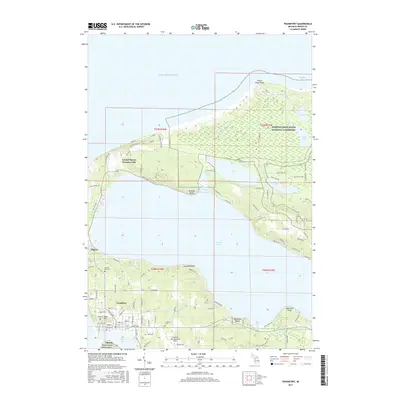
2017 Map of Frankfort
USGS Topo · Published 2017About this map
Frankfort and Elberta serve as the coastal anchors of this Benzie County landscape, separated by the waters of Betsie Lake. The area's maritime and recreational identity is defined by the massive presence of Crystal Lake, which dominates the central portion of the sheet. To the north, the protected lands of Sleeping Bear Dunes National Lakeshore preserve the dunes along Lake Michigan and Platte Bay. Local history and genealogy are anchored at Crystal Lake Cem and Lutheran Cem, while aviation history is represented by Frankfort Dow Memorial Field. The topography reveals the complex relationship between the glacial lakes and the larger lakefront, including smaller bodies of water like Loon Lake and Rush Lake tucked behind the primary shoreline.
Find a feature on this map
108 named features on this map. Tap any name to fly to it.
Don’t see what you’re looking for? This feature index may not catch every label — zoom into the map to look around manually.
Map Details
Editions of this 2017 Frankfort Map
This is the sole edition of this map. No revisions or reprints were ever made.
Other maps of this area

1954 · Manitowoc
USGS Topo · 1:250,000

1956 · Frankfort
USGS Topo · 1:62,500

1957 · Empire
USGS Topo · 1:62,500

1958 · Manitowoc
USGS Topo · 1:250,000

1976 · Frankfort SE
USGS Topo · 1:24,000

1976 · Frankfort NW
USGS Topo · 1:24,000

1976 · Frankfort SW
USGS Topo · 1:24,000
1976 · Frankfort NE
USGS Topo · 1:24,000
1983 · Beulah
USGS Topo · 1:25,000
1983 · Empire
USGS Topo · 1:25,000