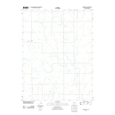
2011 Map of Franklin NE
USGS Topo · Published 2011About this map
Thompson Creek and its various tributaries define the drainage patterns of this Franklin County landscape, reflecting the agricultural and hydrological character of the Nebraska plains. The network is intricately detailed, showing how the West Branch Thompson Creek, Middle Branch Thompson Creek, and East Branch Thompson Creek converge to form the main waterway. This 2011 survey documents the rural infrastructure of the period, anchored in the northwest by Bartels Reservoir and its associated Bartels Dam. The map also captures smaller watercourses like Sassacus Creek in the southeast, illustrating a terrain where seasonal water management and natural creek beds dictate the placement of local roads and property boundaries. For those studying the environmental history of the Republican River watershed, this map provides a clear view of the land before more recent landscape modifications.
Find a feature on this map
7 named features on this map. Tap any name to fly to it.
Don’t see what you’re looking for? This feature index may not catch every label — zoom into the map to look around manually.
Map Details
Editions of this 2011 Franklin NE Map
This is the sole edition of this map. No revisions or reprints were ever made.
Other maps of this area

1897 · Red Cloud
USGS Topo · 1:125,000

1940 · Red Cloud
USGS Topo · 1:62,500

1942 · Red Cloud
USGS Topo · 1:62,500

1955 · Grand Island
USGS Topo · 1:250,000

1957 · Grand Island
USGS Topo · 1:250,000

1958 · Grand Island
USGS Topo · 1:250,000

1969 · Upland
USGS Topo · 1:24,000

1969 · Upland SE
USGS Topo · 1:24,000
1969 · Campbell
USGS Topo · 1:24,000
1973 · Macon
USGS Topo · 1:24,000