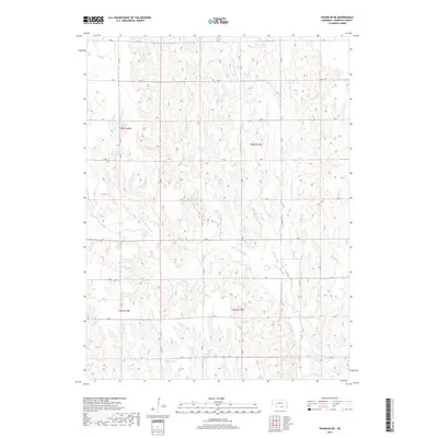
2017 Map of Franklin NE
USGS Topo · Published 2017About this map
Bartels Reservoir and the complex drainage system of Thompson Creek dominate this portion of the Nebraska landscape in the early 21st century. The terrain is defined by a dendritic network of seasonal and perennial waterways, including the Middle Br Thompson Cr and E Br Thompson Cr, which converge as they flow toward the Republican River valley to the south. This area, located across townships T2N and T3N, showcases the characteristic section-line road grid of the Great Plains, where routes like Q Rd and 37 Rd partition the agricultural land. The intricate contour lines reveal the dissected upland character of the region, where numerous draws and ridges have shaped the local hydrology, notably around the W Br Thompson Cr and the eastern reaches of Sassacus Cr.
Find a feature on this map
27 named features on this map. Tap any name to fly to it.
Don’t see what you’re looking for? This feature index may not catch every label — zoom into the map to look around manually.
Map Details
Editions of this 2017 Franklin NE Map
This is the sole edition of this map. No revisions or reprints were ever made.
Other maps of this area

1897 · Red Cloud
USGS Topo · 1:125,000

1940 · Red Cloud
USGS Topo · 1:62,500

1942 · Red Cloud
USGS Topo · 1:62,500

1955 · Grand Island
USGS Topo · 1:250,000

1957 · Grand Island
USGS Topo · 1:250,000

1958 · Grand Island
USGS Topo · 1:250,000

1969 · Upland
USGS Topo · 1:24,000

1969 · Upland SE
USGS Topo · 1:24,000
1969 · Campbell
USGS Topo · 1:24,000
1973 · Macon
USGS Topo · 1:24,000