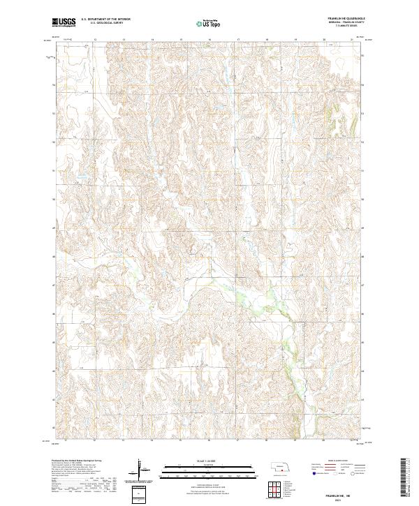
2021 Map of Franklin NE
USGS Topo · Published 2021About this map
Bartels Reservoir and the headwaters of the Thompson Creek drainage system define this agricultural landscape in Franklin. The map illustrates a strictly organized section-line road network, including routes like K Rd and 37 Rd, which partition the undulating terrain of the Republican River valley uplands. Water is the primary geographic driver here, with Middle Br Thompson Cr, W Br Thompson Cr, and E Br Thompson Cr converging as they flow southward. The presence of Sassacus Cr in the southeast corner further emphasizes the importance of these small draws and tributaries to the local drainage and land use patterns.
Find a feature on this map
26 named features on this map. Tap any name to fly to it.
Don’t see what you’re looking for? This feature index may not catch every label — zoom into the map to look around manually.
Map Details
Editions of this 2021 Franklin NE Map
This is the sole edition of this map. No revisions or reprints were ever made.
Other maps of this area

1897 · Red Cloud
USGS Topo · 1:125,000

1940 · Red Cloud
USGS Topo · 1:62,500

1942 · Red Cloud
USGS Topo · 1:62,500

1955 · Grand Island
USGS Topo · 1:250,000

1957 · Grand Island
USGS Topo · 1:250,000

1958 · Grand Island
USGS Topo · 1:250,000

1969 · Upland
USGS Topo · 1:24,000

1969 · Upland SE
USGS Topo · 1:24,000
1969 · Campbell
USGS Topo · 1:24,000
1973 · Macon
USGS Topo · 1:24,000