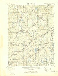
1921 Map of Franklin
USGS Topo · Published 1942About this map
Medfield Junc and Walpole Junction serve as the primary rail hubs for this early 20th-century landscape where industrial villages are spaced along the river systems. The Charles River winds through the center of the sheet, powering settlements like City Mills and Rockville. Significant water management for local industry and municipal needs is evident in the numerous impoundments such as Jenks Reservoir, Reservoir No. 4, and the Shepardville Reservoir.
Find a feature on this map
97 named features on this map. Tap any name to fly to it.
Don’t see what you’re looking for? This feature index may not catch every label — zoom into the map to look around manually.
Map Details
Editions of this 1921 Franklin Map
This is the sole edition of this map. No revisions or reprints were ever made.
Other maps of this area

1885 · Taunton
USGS Topo · 1:62,500

1886 · Blackstone
USGS Topo · 1:62,500

1886 · Dedham
USGS Topo · 1:62,500

1886 · Framingham
USGS Topo · 1:62,500

1887 · Franklin
USGS Topo · 1:62,500

1887 · Providence
USGS Topo · 1:62,500

1887 · Marlboro
USGS Topo · 1:62,500

1888 · Taunton
USGS Topo · 1:62,500

1889 · Providence
USGS Topo · 1:62,500

1889 · Marlboro
USGS Topo · 1:62,500