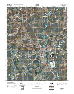
2010 Map of Franklin
USGS Topo · Published 2010About this map
Franklin and its surrounding Tidewater landscape are defined by the winding course of the Blackwater River, which separates the city from neighboring Lees Mill and Kingsdale. This 2010 survey illustrates the area's development, showing a mix of residential expansion in Hunterdale and Cypress Manor alongside established industrial and infrastructure footprints like Franklin Municipal-John Beverly Rose Airport. The map traces the historical and natural boundaries formed by Cypress Swamp and the Nottoway River at Sycamore Bend, while the city center remains anchored by the Franklin Post Office and Poplar Springs Cemetery. Genealogists will find value in the detailed locations of burial sites such as Franklin Municipal Cemetery and local landmarks like Watkins Corner and Maynards Crossroads. The network of backroads, including Joyners Bridge Rd and Sycamore Church Rd, provides a clear view of the rural-to-urban transition throughout Southampton County.
Find a feature on this map
63 named features on this map. Tap any name to fly to it.
Don’t see what you’re looking for? This feature index may not catch every label — zoom into the map to look around manually.
Map Details
Editions of this 2010 Franklin Map
This is the sole edition of this map. No revisions or reprints were ever made.
Other maps of this area

1919 · Homeville
USGS Topo · 1:48,000

1919 · Boykins
USGS Topo · 1:48,000

1920 · Holland
USGS Topo · 1:62,500

1920 · Ivor
USGS Topo · 1:62,500

1920 · Homeville
USGS Topo · 1:62,500

1920 · Boykins
USGS Topo · 1:62,500

1943 · Holland
USGS Topo · 1:62,500

1943 · Vicksville
USGS Topo · 1:31,680

1944 · Sedley
USGS Topo · 1:24,000

1944 · Zuni
USGS Topo · 1:24,000