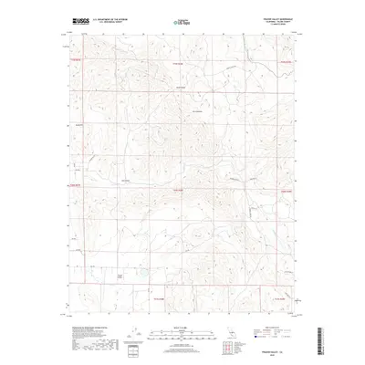
2018 Map of Frazier Valley
USGS Topo · Published 2018About this map
Yokohl Valley and the Frazier Valley characterize this section of Tulare County, where the lower elevations of the Sierra Nevada rise from the eastern edge of the San Joaquin Valley. The landscape is defined by the drainage patterns of Yokohl Cr, Lewis Cr, and Frazier Cr, which cut through the Rocky Hills and Oat Canyon. The road network is established around local rural routes such as Yokohl Valley Dr and several residential lanes including Runner Ln and Campbell Creek Dr. This layout reflects a period of modern rural habitation and agriculture in the foothills, where property boundaries are meticulously organized into townships and ranges, such as t20s r28e. The terrain transitions from relatively flat valley floors to the undulating slopes of the Sierras, illustrating the geographic boundary between California's agricultural heartland and its mountain wilderness.
Find a feature on this map
31 named features on this map. Tap any name to fly to it.
Don’t see what you’re looking for? This feature index may not catch every label — zoom into the map to look around manually.
Map Details
Editions of this 2018 Frazier Valley Map
This is the sole edition of this map. No revisions or reprints were ever made.
Other maps of this area

1904 · Kaweah
USGS Topo · 1:125,000

1909 · Kaweah
USGS Topo · 1:125,000

1925 · Rocky Hill
USGS Topo · 1:31,680

1927 · Rocky Hill
USGS Topo · 1:31,680

1928 · Lindsay
USGS Topo · 1:31,680

1929 · Porterville
USGS Topo · 1:31,680

1937 · Kaweah
USGS Topo · 1:125,000
1942 · Porterville
USGS Topo · 1:62,500

1948 · Fresno
USGS Topo · 1:250,000
1951 · Porterville
USGS Topo · 1:24,000