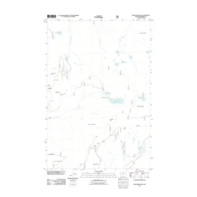
2011 Map of Fred Burr Lake
USGS Topo · Published 2011About this map
Granite stands as a focal point of historical mining activity in this high-altitude region of Montana. The settlement is surrounded by a dense concentration of hard-rock workings, including the Granite Mountain Mine, Fraction Mine, and Big Expectation Mine, illustrating the intense industrial extraction that once defined the local economy. Water management for these operations and the surrounding area is evidenced by the Fred Burr Lake Dam and the Big Racetrack Lake Dam, which regulate the flow of Fred Burr Creek and adjacent alpine basins. The landscape is characterized by prominent peaks such as Red Lion Mountain and Rumsey Mountain, where the Discovery Basin Ski Area now utilizes the steep terrain. A network of forest roads like Co RD 5159 and Co RD 8445 provides access to remote sites like the Nut Pine Mine and various high-country water bodies including Crystal Lake and Dora Thorn Lake.
Find a feature on this map
42 named features on this map. Tap any name to fly to it.
Don’t see what you’re looking for? This feature index may not catch every label — zoom into the map to look around manually.
Map Details
Editions of this 2011 Fred Burr Lake Map
This is the sole edition of this map. No revisions or reprints were ever made.
Other maps of this area

1908 · Philipsburg
USGS Topo · 1:125,000

1947 · Butte
USGS Topo · 1:250,000

1958 · Butte
USGS Topo · 1:250,000

1960 · Butte
USGS Topo · 1:250,000

1962 · Butte
USGS Topo · 1:250,000

1971 · Henderson Mountain
USGS Topo · 1:24,000

1971 · Georgetown Lake
USGS Topo · 1:24,000
1971 · Pikes Peak
USGS Topo · 1:24,000
1971 · Maxville
USGS Topo · 1:24,000
1971 · West Valley
USGS Topo · 1:24,000