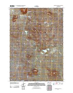
2011 Map of Frederick Butte
USGS Topo · Published 2011About this map
Frederick Butte and several prominent neighboring rises define this high-desert landscape in Deschutes County during the early 21st century. The map reveals an intricate network of intermittent water features and ephemeral lakes characteristic of the Oregon interior, including the curiously named Concentration Reservoir Number Three and Little Benjamin Lake. The terrain is marked by volcanic topography such as Indian Butte and No Name Butte, with the drainage of Peters Creek winding through the central basin. Human infrastructure is limited to long-distance desert routes like Lost Forest Rd and Chicago Valley Rd, reflecting the region's sparse ranching or conservation character. Rare water sources like Hayes Spring appear as vital landmarks in an otherwise arid environment, providing a detailed look at the hydrology before the modern shift in high-desert climate patterns.
Find a feature on this map
18 named features on this map. Tap any name to fly to it.
Don’t see what you’re looking for? This feature index may not catch every label — zoom into the map to look around manually.
Map Details
Editions of this 2011 Frederick Butte Map
This is the sole edition of this map. No revisions or reprints were ever made.
Other maps of this area

1955 · Crescent
USGS Topo · 1:250,000

1957 · Crescent
USGS Topo · 1:250,000

1958 · Crescent
USGS Topo · 1:250,000

1970 · Crescent
USGS Topo · 1:250,000

1981 · Moonlight Butte
USGS Topo · 1:24,000

1981 · Mean Rock Well
USGS Topo · 1:24,000

1982 · Peters Creek Sink
USGS Topo · 1:24,000
1983 · Soldiers Cap
USGS Topo · 1:24,000

1983 · Imperial Valley South
USGS Topo · 1:24,000

1983 · Benjamin Lake
USGS Topo · 1:24,000