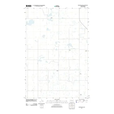
2011 Map of Fredonia NW
USGS Topo · Published 2011About this map
Family and ethnic legacies define this portion of Gutschmidt Township, where a high density of small cemeteries marks the prairie landscape. The map reveals the settlement patterns of Logan County through sites such as Emanuel Cemetery and the Finnish Cemetery, which point to the diverse immigrant history of the region. The terrain is a complex network of small wetlands and depressions characteristic of the Missouri Coteau, crisscrossed by a strict section-line road grid including 59th Ave SE and 64th St SE. Genealogists will find significant value in the distribution of burial grounds like Labrenz Cemetery, Wolff Cemetery, and Eszlinger Cemetery, which serve as primary landmarks in this sparsely populated agricultural area. The absence of a central town on this sheet emphasizes the importance of these rural congregational and family sites as the anchors of the local community.
Find a feature on this map
18 named features on this map. Tap any name to fly to it.
Don’t see what you’re looking for? This feature index may not catch every label — zoom into the map to look around manually.
Map Details
Editions of this 2011 Fredonia NW Map
This is the sole edition of this map. No revisions or reprints were ever made.
Other maps of this area

1953 · Jamestown
USGS Topo · 1:250,000

1956 · Jamestown
USGS Topo · 1:250,000

1982 · Fredonia NW
USGS Topo · 1:24,000

1982 · Guyson
USGS Topo · 1:24,000

1982 · Fredonia
USGS Topo · 1:24,000

1982 · Lehr NE
USGS Topo · 1:24,000

1982 · Fredonia NE
USGS Topo · 1:24,000
1982 · Lehr
USGS Topo · 1:24,000

1983 · Alfred
USGS Topo · 1:24,000

1983 · Streeter SE
USGS Topo · 1:24,000