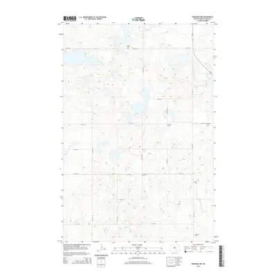
2014 Map of Fredonia NW
USGS Topo · Published 2014About this map
Small rural cemeteries and numerous prairie potholes characterize this corner of Logan County, where the section-line road grid organizes a landscape of low hills and seasonal wetlands. The high concentration of family and community burial grounds, such as Emanuel Cem, Finnish Cem, and Friedenthal Cem, suggests a history of localized ethnic and family-centered settlement common to the Dakotas. State highway ND-56 runs along the eastern edge of the quadrangle, serving as the primary corridor through this agricultural expanse. The intricate contour work reveals the terminal moraine topography, with many small basins and ephemeral water bodies that influenced the placement of roads like 64th St SE and 59th Ave SE. For researchers, the presence of Labrensz Cem, Wolff Cem, and Eszlinger Cem provides precise points for tracing early 20th-century lineages in Gutschmidt Township.
Find a feature on this map
19 named features on this map. Tap any name to fly to it.
Don’t see what you’re looking for? This feature index may not catch every label — zoom into the map to look around manually.
Map Details
Editions of this 2014 Fredonia NW Map
This is the sole edition of this map. No revisions or reprints were ever made.
Other maps of this area

1953 · Jamestown
USGS Topo · 1:250,000

1956 · Jamestown
USGS Topo · 1:250,000

1982 · Fredonia NW
USGS Topo · 1:24,000

1982 · Guyson
USGS Topo · 1:24,000

1982 · Fredonia
USGS Topo · 1:24,000

1982 · Lehr NE
USGS Topo · 1:24,000

1982 · Fredonia NE
USGS Topo · 1:24,000
1982 · Lehr
USGS Topo · 1:24,000

1983 · Alfred
USGS Topo · 1:24,000

1983 · Streeter SE
USGS Topo · 1:24,000