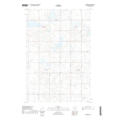
2017 Map of Fredonia NW
USGS Topo · Published 2017About this map
The northern prairies of Logan County are characterized here by a dense network of sectional roads and small wetland basins. The landscape is dotted with several significant local landmarks for genealogical research, including the Emmanuel Congregational Cem and the Finnish Cem. These small burial grounds, alongside others like the Friedenthal Cem and Labrenz Cem, reflect the settlement patterns and heritage of the families who worked these townships. The map details the rural infrastructure of the early 21st century, where routes like 64th St SE and 60th Ave SE connect isolated farmsteads across the undulating terrain. A distinct family history element is visible in the southeastern corner with the Eslinger Family Cem, illustrating the personal scale of land ownership and commemoration in this part of North Dakota.
Find a feature on this map
22 named features on this map. Tap any name to fly to it.
Don’t see what you’re looking for? This feature index may not catch every label — zoom into the map to look around manually.
Map Details
Editions of this 2017 Fredonia NW Map
This is the sole edition of this map. No revisions or reprints were ever made.
Other maps of this area

1953 · Jamestown
USGS Topo · 1:250,000

1956 · Jamestown
USGS Topo · 1:250,000

1982 · Fredonia NW
USGS Topo · 1:24,000

1982 · Guyson
USGS Topo · 1:24,000

1982 · Fredonia
USGS Topo · 1:24,000

1982 · Lehr NE
USGS Topo · 1:24,000

1982 · Fredonia NE
USGS Topo · 1:24,000
1982 · Lehr
USGS Topo · 1:24,000

1983 · Alfred
USGS Topo · 1:24,000

1983 · Streeter SE
USGS Topo · 1:24,000