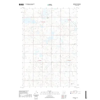
2020 Map of Fredonia NW
USGS Topo · Published 2020About this map
Scattered cemeteries and family burial plots define this section of Logan County, reflecting the deep ties of the early homesteading families to this prairie landscape. The area is divided by the Township and Range lines of t135n r68w, t135n r67w, t134n r68w, and t134n r67w. These administrative boundaries, while invisible on the ground, dictated the placement of a grid-like road network including 64th St SE and 59th Ave SE. The presence of the Emmanuel Congregational Cem and the Finnish Cem points toward the diverse immigrant heritage of the settlers who established small rural congregations across these townships. Much of the land remains dominated by the natural depressions and wetlands characteristic of the region, interspersed with named landmarks like the Labrenz Cem and Wolff Cem that serve as vital touchstones for genealogical research.
Find a feature on this map
22 named features on this map. Tap any name to fly to it.
Don’t see what you’re looking for? This feature index may not catch every label — zoom into the map to look around manually.
Map Details
Editions of this 2020 Fredonia NW Map
This is the sole edition of this map. No revisions or reprints were ever made.
Other maps of this area

1953 · Jamestown
USGS Topo · 1:250,000

1956 · Jamestown
USGS Topo · 1:250,000

1982 · Fredonia NW
USGS Topo · 1:24,000

1982 · Guyson
USGS Topo · 1:24,000

1982 · Fredonia
USGS Topo · 1:24,000

1982 · Lehr NE
USGS Topo · 1:24,000

1982 · Fredonia NE
USGS Topo · 1:24,000
1982 · Lehr
USGS Topo · 1:24,000

1983 · Alfred
USGS Topo · 1:24,000

1983 · Streeter SE
USGS Topo · 1:24,000